#13: Lessons writ in limestone - the Philippines
Dear Reader,
In July-August 2022, I had the fortune to travel to the Philippines for twenty days, during which I visited two incredible geoheritage sites (three: if you count the Taal volcano but it was more of a photo-stop).
The archipelago country holds so much inspiration for the intrepid, nerdy traveller. Its 7,107 islands have been shaped, and continue to be shaped by the active volcanoes and frequent earthquakes that define the Pacific Ring of Fire — the world's most active tectonic zone. The Philippines is a fascinating mosaic of steep, volcanic peaks, lush rainforests and island biomes rich with endemic biodiversity, coral reefs teeming with colourful marine life, and limestone labyrinths where new species are still being discovered.In July 2022, the Geological Survey of India (GSI) announced that it plans to open up 90 sites with rich natural history for geotourism. The news, while heartening, also raised concerns as we have been notoriously poor sentinels in preserving our landscapes and natural heritage. How can we ensure that these sites not just provide additional revenue to the government, but further the objectives of education, awareness, landscape conservation, and inspire scientific research?
This excerpt draws inspiration from two geoheritage sites, one a UNESCO World Heritage Site, and another a community-led initiative, to sift what lessons we can for the future of India's geotourism sites.
THE PHILIPPINES - AN INTRODUCTION
The geology of the Philippines is rather complex, as it is defined by the interaction between 4 tectonic plates: the Eurasian plate, the Pacific plate, the Indo-Australian plate and the tiny Sunda plate. This has resulted in fascinating landscapes of metamorphic rocks, subduction— where one plate slides underneath another and is marked by a line of volcanoes, ophiolites— a snake-like rock that is a fragment of oceanic crust that sits atop continental crust, sedimentary basins shaped by river networks, and karst formed where corals accumulate over time and give rise to limestone features, among others.
The earth-shaping processes playing out over millennia, have resulted in the spectacular diversity of life and landscapes, both on land and underwater. For anyone visiting the Philippines, I would highly recommend a visit to the National Museum of Natural History in Manila — where exhibits cover the geography and geology of the islands, the different habitats of karst crags, coral reefs, pygmy forests, rainforests, volcanic craters, mangrove swamps, and the flora and fauna that define each. Locals and foreigners can access the museum for free — the rich collections and detailed exhibits are the perfect introduction to the Philippines.
MASUNGI GEORESERVE
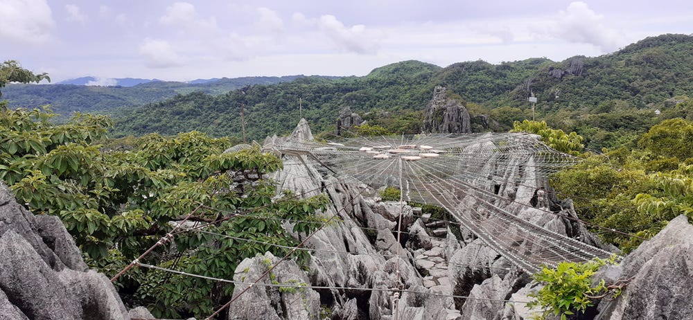
A metal-and-rope web built above the fragile karst landscape in Masungi Georeserve, inspired by the intricate designs woven by some of its residents — the giant wood spiders. Image credits: Devayani Khare
A ~2-hour drive from the heart of Manila, a road through lush forests brings you to the Masungi Georeserve. Defined by ashy limestone crags, this once-denuded landscape was stark and barren as a result of land-grabbing activities for resorts and private residences, illegal logging of timber, and large-scale quarrying. Some quarries are still visible on the route to the georeserve — a reminder of the odds fought to conserve and restore this natural heritage site.
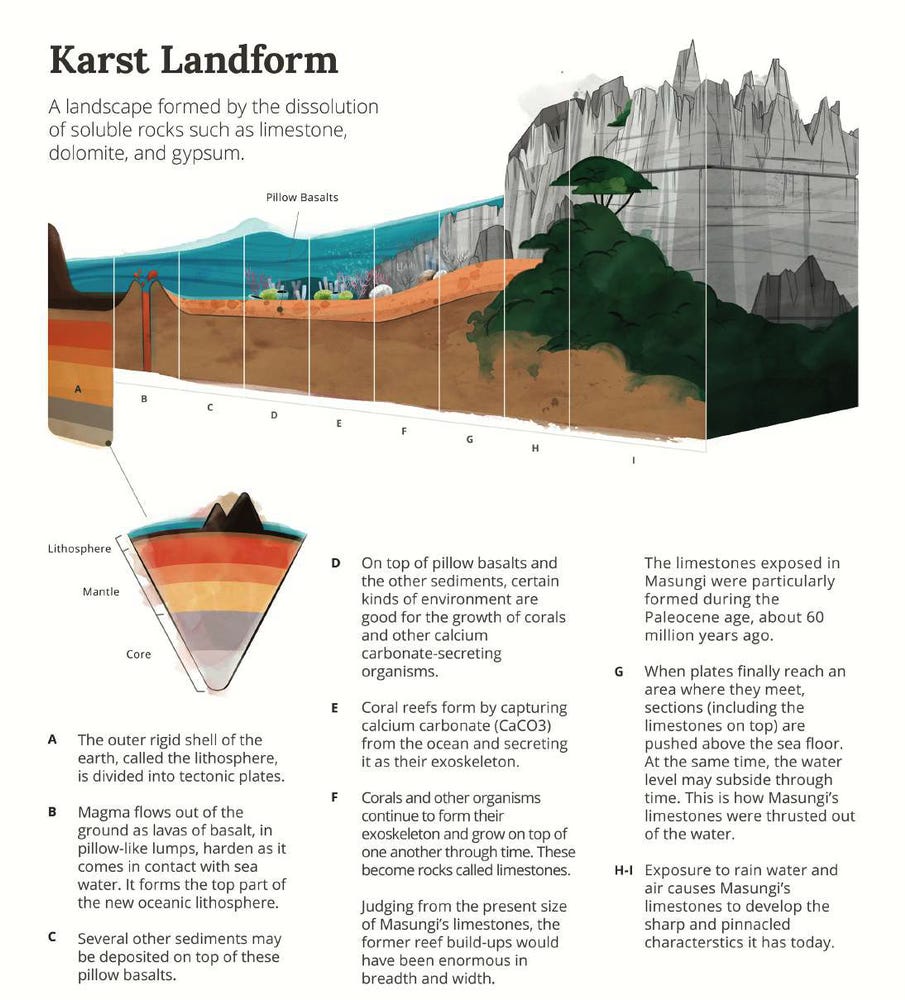
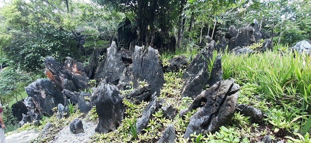
The name 'masungi' is derived from the local word 'masungki' meaning spiked or crooked, jagged teeth — an apt term to describe the staggering karst formations. Karst formations, as I've written before (as landscapes etched by rain and karst landscapes as geoheritage) are formed by the dissolution of rocks like limestone, dolomite and gypsum, which were formed by the age-old accumulation of corals. Here is an explanation from an info-kit published by the Masungi Georeserve:
The fascinating process by which karst landscapes are formed, from their watery beginning to their rain-carved present. Image credits: Masungi Georeserve
Masungi Georeserve is a sustained effort by a passionate group of individuals, in the face of threats from environmental offenders, and even the death of rangers (Intrigued? Read the news here). Anchored by the foundation body of Masungi Georeserve and funded by a private corporation, this is a unique project based on 3 pillars: conservation, education, and sustainable development.
PUERTO PRINCESA SUBTERRANEAN RIVER
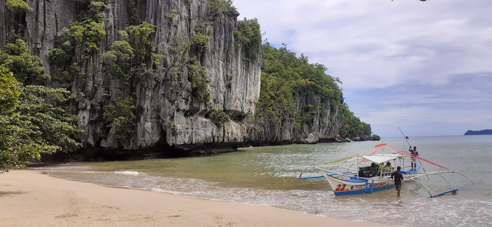
A motorboat ride from Sabah beach past ashy limestone crags, leads you to the tiny sandy island from where you can access the mouth of the Puerto Princesa subterranean river. This is the main attraction in the Palawan island province in the Philippines. Image credits: Devayani Khare.
An hour's flight from Manila, bearing due southwest, is the archipelago province of Palawan with Puerto Princesa as the major town. Palawan's islands are known as the last frontier of the Philippines as they represent the westernmost limit beyond which the rest of Asia lies. Palawan's islands offer everything from rainforest-draped mountains to white sandy beaches, from riverine networks to coral reefs.
To the north of Palawan island, born deep within limestone spires, the Puerto Princesa river runs beneath old-growth forests, carving a spectacular labyrinth of caves as it flows towards the sea. A UNESCO World Heritage Site recognised for both its karst formations and its mountain-to-sea ecosystem, a visit to the Puerto Princesa subterranean river national park is an enthralling experience. I had planned my visit to coincide with my birthday — and what others might have thought of as spooky, a river cruise through a dark cave of chittering bats and bizarre limestone formations — was an absolute delight for me.
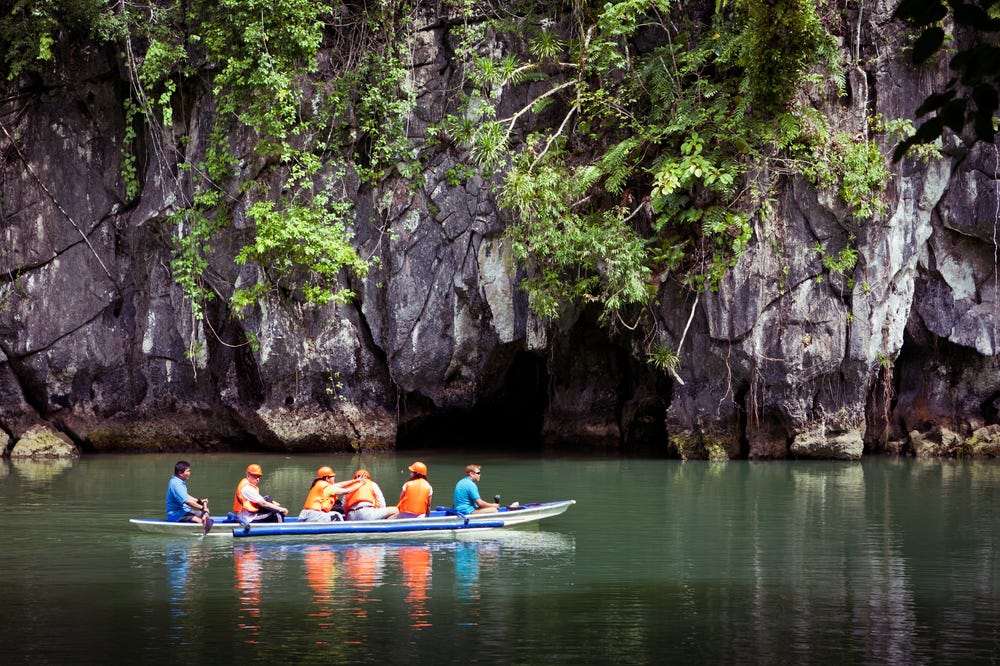
While boarding the canoe with our bright life jackets, we were given an audio guide with a single-earpiece set and instructions for the cruise. No talking, no laughing, no loud sounds. The single-earpiece set meant that we could listen to a beautiful narration about the caves, their geology, the biodiversity, and the imaginative names given to various formations, as also the staccato calls of the bats and swallows, the eerie drips and gushes of water that made its way from the slick roof to the river below, and the slow lapping of the boat as it made its way past the incredible formations.
An outrigger canoe gently takes you into the maw of the limestone labyrinth created by the underground Puerto Princesa river. Image credits: Benson Kua (CC BY-SA, via Wikimedia Commons)
As a geoheritage site, the Puerto Princesa subterranean river national park is managed by the local Palawan/Philippine government. As a geological site, it is important to preserve the karst landscape, the dramatic speleothems, and the fresh-to-brackish water channel of the river. As a biodiversity site, the national park covers 8 different kinds of forest formations — and is the largest karst forest in Asia, with high levels of local and regional endemism. Interestingly, tourism has been identified as a potential threat as karst landscapes are adversely affected by human activity, movement and development. Activities are strictly regulated with a per day limit of visitors, a river cruise designed to create minimal impact, a revenue model that benefits the locals (via the boats to the island and into the caves, and the lunch), and regular wildlife population surveys to monitor the effects of tourism. Visitors are further encouraged to visit a nearby community-run initiative that includes caving and ziplining. Management plans also cover the threats from agriculture, forest clearing, mining, and pollution.
LESSONS FROM THE PHILIPPINES
Between these two geotourism initiatives, there were a few interesting lessons to be learned:
Non-intrusive, non-destructive approach to showcasing the geological formations: karst landscapes are fragile and easily damaged. In Masungi, the rangers have made a concerted effort to design ropeways, bridges, walkways and dedicated paths to allow you to explore the park. It is quite an adventure making your way across the dangling, suspended bridges and the knotted, woven nets that offer views of the sheer landscape below (if like me, you have a fear of heights). A local guide accompanies you throughout the trail, drawing your attention to the interesting rock formations, the flora and fauna, and the fragility of the landscape you've ventured into. Similarly, on the Puerto Princesa river cruise, the audio guides and rowed canoes ensure minimal noise and disturbance. The boatsmen are adept at navigating past the cave formations without damaging them, and deftly shining their light onto features of interest.
With every geoheritage site, it would be crucial to identify the highlights and pain points for the landscape to better design activities that allow visitors to learn more while causing minimum impact.
Landscape & habitat conservation: apart from conserving the fragile karst landscapes, both initiatives are also committed to protecting the biodiversity that inhabits each landscape, some of it endemic - found only in the Philippines and nowhere else on earth. In Masungi, that includes the micro-snails and the Philippine Luzon hornbill, and everything in between (short read on the endemic life at Masungi). The Puerto Princesa national park is home to 6 species of bats, 30 mammals, 195 birds, and a giddying range of invertebrates. As it encompasses 8 kinds of forests, it is also a rich repository of the rare, endemic flora of the Philippines.
A landscape-level approach to geoheritage sites, where both the geography and the biodiversity are considered important natural resources, would allow for more integrated, holistic conservation plans.
The approach to Masungi Georeserve, landscaped around signature masungki or jagged teeth formations. Image credits: Devayani Khare.
Educational and scientific value: geoheritage sites are not just worth conserving for their aesthetic value. They also serve as examples of geological or geomorphological processes, by offering insights into the evolution of the earth, and the processes that shaped landscapes. As a habitat, geoheritage sites often throw up interesting scientific discoveries: as refuges for rare, endemic biodiversity (the micro-snails in Masungi), or the discovery of new species (a new huntsman spider and 3 begonia species in Puerto Princesa). These can lead to interesting insights in the fields of biogeography, ecology, landscape evolution, climatology and even planetary sciences (as proxy environments to study the Moon/Mars). Identifying and highlighting the educational and scientific value would allow landscapes to be seen as more than just tourism sites, but as ones that can further our understanding in different disciplines.
Ecosystem services: Geological features also perform important ecosystem services: carbon sequestration (mineral and marine), abiotic soil formation, hazard protection, and freshwater reserves, among others. For instance, Masungi's karst landscape not only serves as a natural filter for Metro Manila's water supply, but its forests also play a vital role in mitigating the impacts of floods and landslides. Effective reforestation, watershed management and landscape conservation allow Masungi to counter biodiversity loss, water crises, and climate change. The Puerto Princesa river watershed is crucial for local towns and agriculture, and it also supports a rich mosaic of forests with plants of medicinal and ecological value. It is important to identify and raise awareness about these if we are keen on the landscape being preserved for more than just aesthetic reasons.
Lastly, documenting and showcasing the geological, ecological, educational, and cultural aspects of geoheritage sites is crucial in designing effective conservation plans, with the local communities as custodians.
RELATED POSTS


What a beautifully detailed exploration of geoheritage conservation! I love how you've woven together the geological science with practical conservation lessons. Thank you for this thoughtful piece - it's given me a whole new appreciation for the Philippines beyond the typical beach paradise narrative.