Dear Reader,
There's a reason why monsoons have long been a part of popular imagination. Rains have inspired myths and music, art and literature. In Indian mythology alone, there are several deities associated with the rain; Indra, Varuna, Varshini, Surupa, Mariamman. As per the Ṛg Veda, even the raincloud Parjanya is considered divine - he brings the life-giving rain in the form of a furious bull or a cow with heavy udders, accompanied by three voices; lightning, thunder and rain. From the Hindustani classical rāga, Malhār associated with torrential rains, or the many indigenous styles of paintings depicting the rains, or the 4th-5th CE lyric poem, Meghdootam penned by Kālidāsa - rains are an integral part of our culture.
So where do the monsoons come from? What is different about the Indian monsoon?
This excerpt hopes to trace the journey of the monsoons, and the global factors that cause them to vary. It is a rather complicated system with many variables, it is difficult to draw a line between oversimplifying and over-complicating. I hope to capture the nuance as best as I can.
RAIN AS THE ELIXIR OF LIFE
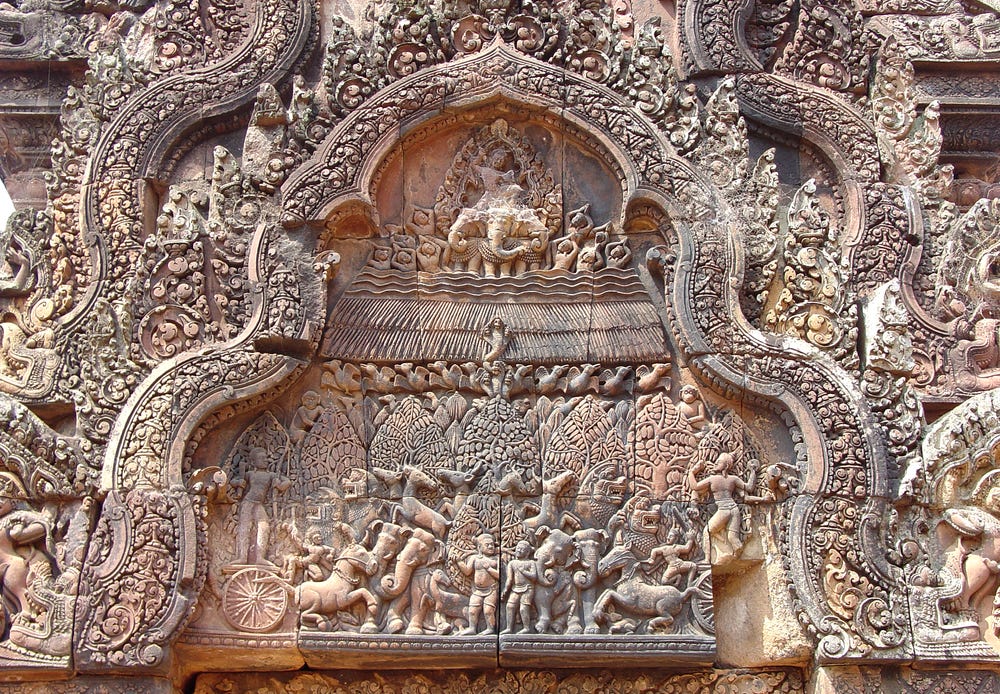
A panel detailing the burning of the Khandava forest with Lord Indra sitting atop Airavata, his elephant. Indra is creating rain to help his friend, Takshaka, the king of the Nagas (snakes). This panel is part of the east pediment in the north library at Banteay Srei (pavilion of women) in Cambodia. Image credits: Michael Gunther, CC BY-SA via Wikimedia Commons.
नवमासधृतं गर्भं भास्करस्य गभस्तिभिः। पीत्वा रसं समुद्राणां द्यौः प्रसूते रसायनम्॥ Nava-māsa-dhṛtaṃ garbhaṃ bhāskarasya gabasthibhiḥ | Pītvā rasaṃ samudrāṇāṃ dyauḥ prasūte ras’-āyanam || Translation: For nine months, the sky drank the ocean’s water, sucking it up through the sun’s rays, and now gives birth to a liquid offspring, the elixir of life. Rāmāyaṇa, 4.27.3 – Vālmīki School geography taught us that monsoon winds represent a seasonal reversal of land-sea breezes where the moisture-laden winds from the Indian Ocean, are diverted as they pass the equator, and move towards the Indian subcontinent.
Over the summer months, the Tibetan plateau located 4000 metres above sea level, experiences a different degree of heating, and a low-pressure zone develops over it. The monsoon cycle, as we know it, starts over the large expanse of the Indian Ocean - where through the year, especially in the summer months, water evaporates. While these are key parts of the Indian monsoon system, there's a more complicated mechanism of atmospheric and oceanic circulations at play.
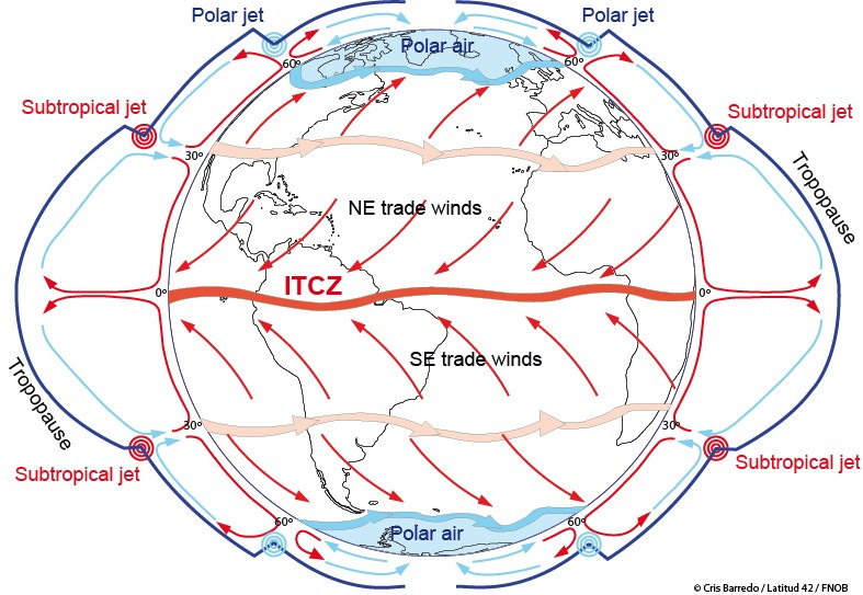
The Intertropical Convergence Zone (ITCZ - pronounced as 'itch') Encircling the thermal equator, where the northeast and southeast trade winds converge - lies a zone of calm, monotonous weather often discernible on satellite images as a band of clouds - known as the intertropical convergence zone. In sailor speak, this zone is also known as the doldrums (As an idiom, 'to be in the doldrums' means a spell of listlessness or despondency). I've used the term 'thermal equator' as this isn't always aligned with the equator but changes seasonally, with the apparent migration of the sun from the equator to the two tropics of Cancer (northern hemisphere) and Capricorn (southern hemisphere). The differential heating of the Tibetan Plateau and the apparent motion of the sun towards the Tropic of Cancer means the ITCZ shifts northwards during the summer months. This shifting of the ITCZ determines the wet and dry spells in equatorial countries and influences the Indian monsoon. The low-pressure zone over the Indian subcontinent, and that of the Tibetan plateau lure the southeast trade winds across the equator. As the winds cross the equator, they change direction due to the Coriolis effect (caused by the spin of the Earth around its axis), and hence, reach the western coast of India.
EL NIÑO & LA NIÑA
So where do the moisture-laden winds that reach India originate?
Despite its distance, the Pacific Ocean plays a significant role in the Indian monsoon.
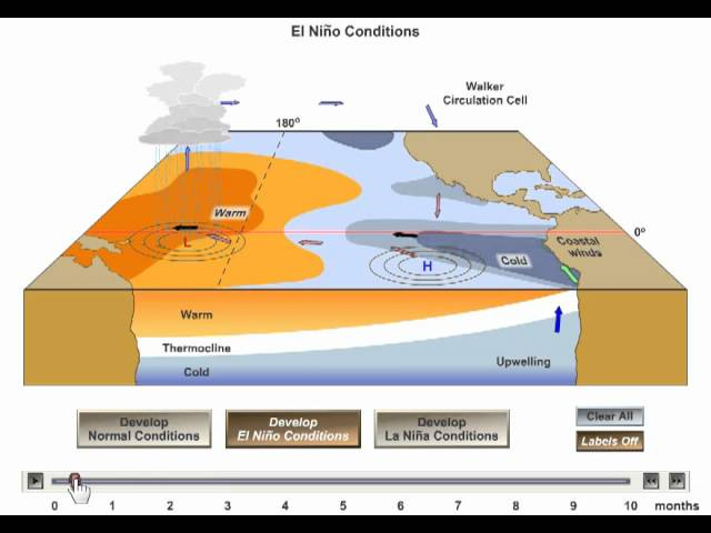
Usually, through the summer, the coast of Peru with its cool Peruvian or Humboldt currents experiences a high-pressure zone, as compared to southeast Asia. As the Indian Ocean is warmer than the adjoining oceans, moisture-bearing winds migrate from the western Pacific Ocean to the Indian Ocean.
Some years, however, in late December, there is a large-scale warming of the ocean surface near the equator. This results in a warm ocean current along the South American coastline. This warm El Niño current temporarily replaces the Peruvian or Humboldt currents and creates a low-pressure cell off the coast of Peru. Through summer, this low-pressure cell weakens/distracts the trade winds heading towards India and causes heavy rains in Peru instead. Robbed of the moist trade winds, India receives a weak monsoon in the El Niño years.
Conversely, the Pacific waters sometimes get colder than usual creating a strong high-pressure zone over the eastern equatorial Pacific, known as the La Niña cycle. Comparatively, the Asian landmasses are warmer and none of the trade winds reaches Peru or Ecuador and causes droughts. In the La Niña years, India has a hearty, heavy monsoon.
These cycles of El Niño and La Niña occur every four to five years and can be used to predict the intensity of the Indian monsoon. This cycle is known as the El Niño Southern Oscillation (ENSO - climatologists do love their acronyms!).
Tropical Easterly Jetstream (TEJ) Apart from ocean currents, atmospheric events are also involved in the Indian monsoon. A jetstream is a relatively narrow band of strong wind in the upper reaches of the atmosphere. It can be considered an aerial superhighway along which storms travel. From late June to early September, ~15 kilometres above the Earth's surface (in the upper atmosphere), directly over the Indian Ocean, strong airflows develop. The effects of this tropical easterly jetstream (TEJ) extend from South-East Asia to Africa. As the TEJ flows east to west over Peninsular India, there is a reversal of upper air circulation patterns - the high high-pressure areas switch to low-pressure zones - that lead to a rapid onset of monsoon. The amount of rainfall that India receives is directly dependent on the intensity and duration of the heating of the Tibetan plateau. For instance, if over summer, the snow over the Tibetan plateau has melted, we can expect a strong jetstream and heavy rainfall across India. Yet if any snow persists through summer over the Tibetan plateau, India will have a weak monsoon.
WESTERN GHATS: AN OROGRAPHIC BARRIER
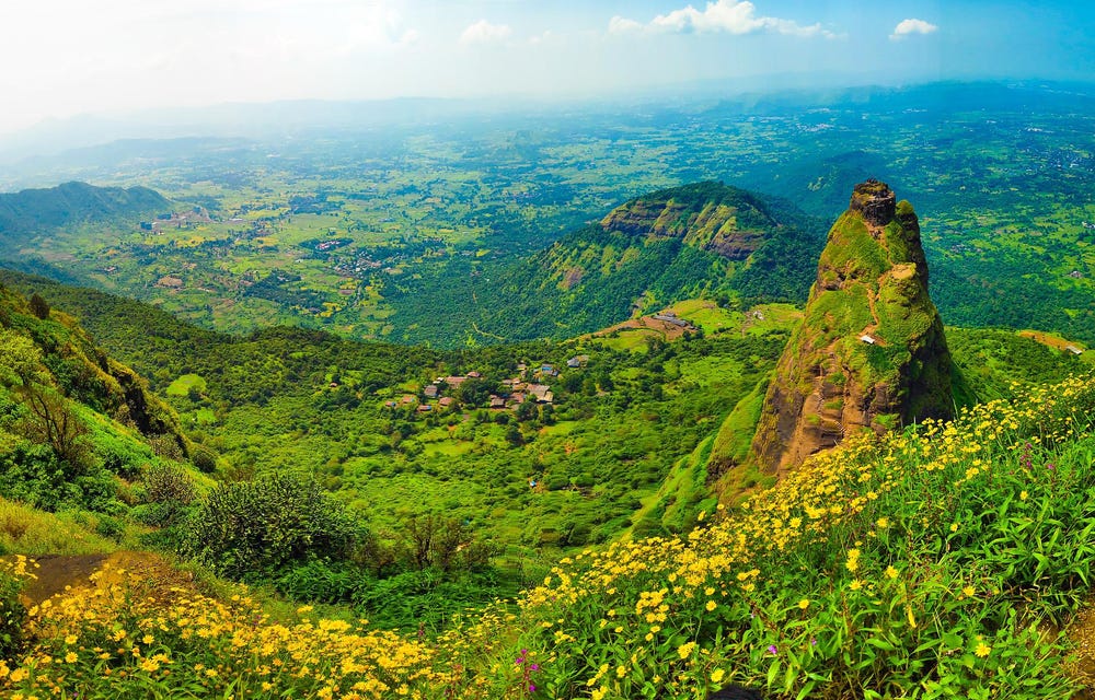
Prabalgad, a fort near Panvel in Mumbai, is perched along the escarpment of the Western Ghats. The Western Ghats pose a barrier to the incoming moisture-laden winds from the Arabian Sea. The lush slopes are a sign of a healthy, diverse, and often endemic ecosystem. Image credit: Ankita_GSD via Pixabay
As the ITCZ and TEJ shift, humid winds from the southwest sweep over the Arabian Sea, hypnotically drawn to the low-pressure zone over the Tibetan plateau - only to be thwarted by the Western Ghats. This escarpment or steep slope that fringes the western peninsular coast of India, reaching heights of up to 2,695 metres (or 8,842 feet) poses a significant barrier to the winds, forcing them to rise over the range. As the moisture-laden winds rise and the air pressure drops, they expand, cool and condense, to rain down in steamy torrents over the western slopes of the Western Ghats.
The eastern slopes, known as rain-shadow areas receive lesser rainfall. Yet over time, enough moisture-laden winds ascend over the Western Ghats to drench the northern plains of India. Recent research has also shown that the evapotranspiration from the vegetation along the Western Ghats may account for 25% of the rainfall experienced in peninsular India.
Indian Ocean Dipole (IOD) & the Equatorial Indian Ocean Oscillation (EQUINOO) Much like the oceanic currents in the Pacific Ocean, the Indian Ocean Dipole (IOD) is caused by alternate warming and cooling cycles in the Indian Ocean along the equator. The IOD results in the Equatorial Indian Ocean Oscillation (EQUINOO - the Indian Ocean equivalent of the ENSO) and determines the cloud formation processes. A positive EQUINOO phase results in better cloud formation and heavier rainfall, whereas a negative phase results in scantier clouds and rainfall. The IOD and EQUINOO can be considered regulators of the Indian monsoon. Local factors like dust particles, aerosols, the area under irrigation, and distant processes like the Atlantic sea surface temperature variations have also been linked to the quirks of the Indian monsoon. However, I feel this provides a broad enough overview of the processes involved, and I will not delve into details about these other factors.
RETREAT/WITHDRAWAL OF THE MONSOON
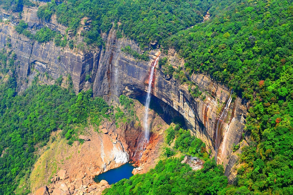
The Nohkalikai Falls in Cherrapunji plunge off the edge of an escarpment to dramatic effect. The rain-fed falls have inspired a tragic local story about a young woman named Likai, who throws herself off the precipice - hence the name, meaning the 'leap of Likai'. The highest rainfall in India is experienced at Cherrapunji in Meghalaya and has shaped its landscape in interesting ways.
Image credit: Sujan Bandyopadhyay, CC BY-SA via Wikimedia Commons
By August, much of the moisture in southwesterly currents has been lost as rain. The constant cloud cover has meant that lesser sunshine can reach the Earth's surface, and the temperatures begin to fall. In September, dry, cool winds from the Tibetan highlands blow towards northwestern India. The tropical easterly jetstream weakens, and both the TEJ and the southwesterly monsoon currents are soon pushed back. The ITCZ that had migrated northwards during the summer months slowly returns to its equatorial position. The monsoon begins to withdraw or retreat.
Rainfall across the subcontinent at this time is highly variable; the southeastern areas, the Bay of Bengal, and the ranges around Cherrapunji continue to experience heavy showers, while there is lesser rain along the western coast. As the monsoon shrugs off from the western and northwestern parts of the country, the eastern coast faces heavy downpours from October to December.
Sometimes, tropical depressions are formed when warm, moist air over the oceans begins to rise. This creates a low-pressure area over the ocean surface, and the surrounding air swirls and creates a strong circulation in the place of the rising air. Tropical depressions and cyclones further complicate the rainfall patterns.
PAST & PRESENT MONSOON PATTERNS
The Indian monsoon has always been erratic and we're only just beginning to understand all the global and local factors that influence it. These complexities also mean that the Indian monsoon is an integral part of the global climate system. What's more, the Indian monsoon affects over a fifth of the world's population. Climate change studies indicate that monsoons will become more erratic and can have devastating effects on the region.
That's why it is just as critical to study past monsoon patterns, as it is to find predictive models that can help us understand what lies ahead. These forecasts can not just help us better plan our water resources and agricultural policies, but will also dictate the economic and political stability of the region.
RELATED POSTS


